|
|
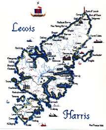
Lewis
& |
|
|
|
||||||||
|
|||||||||
|
Lewis and Harris are not actually separate islands; rather, Lewis forms the top 75% and Harris the bottom 25% of the largest and most northerly of the Western Isles. However, the two are separated by a high ridge of mountains. Here, at the northern end of "The Long Island", Gaelic language and culture are at their strongest. On the west coast of Lewis are the Callanish Standing Stones, three megalithic stone circles probably about 4000 years old. The main site has some 48 stones, the tallest of which is 16 feet high, and which form a rough cross. In the United Kingdom these stones are second only in grandeur to Stonehenge and their lonely and desolate situation on the edge of Europe lends them a particularly mystic atmosphere. As with many stone circles the original purpose of the Callanish stones is unclear; were they perhaps an early astronomical observatory, maybe the "winged temple of the northern isles" referred to by the Greek writer Herodotus in 5BC? They are clear evidence, however, of a strong and flourishing civilisation here many thousands of years ago when the climate was considerably more clement than it is today! Lewis and Harris were ravaged by the Viking invaders in the 9th century and the many place names of Norse origin testify to the Viking influence. It was at Uig on Lewis that the magnificent 12th century walrus ivory Norse chess set was found in the sand dunes Both Lewis and Harris suffered badly under the clearances of the late 18th and early 19th centuries when rapacious greedy landlords moved the islanders off their land to make way for sheep and better profits. This caused hardship, death and appalling and lasting bitterness. Traces of "lazybeds", small plots of poor land which the 18th century crofters attempted to cultivate after they had been expelled from the good land, can still be seen, especially in Harris. As a result of the Clearances many islanders emigrated to the new world although this was not always welcomed by the landlords who still liked to have plenty of retainers and cheap labour available. Lewis and Harris were MacLeod territory. The MacLeods initially held Harris as vassals of Clan Donald, Lords of the Isles, but when the lordship was forfeited they held the islands in their own right and split into two branches, MacLeod of Harris and MacLeod of Lewis. Our map of Lewis and Harris measures 12¾ x 10¼ inches (326 x 260 mm) when stitched on the reocmmended Linda 27-count evenweave. It has 6 buildings, two lighthouses, standing stones, three different ferries, a lifeboat, fishing and sailing boats, place names, and a longship as the compass. The stitch count is 137 x 172.
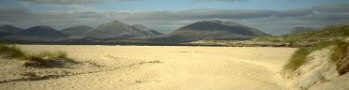
Photograph
of Luskentyre beach reproduced by kind permission of Joanne Mackenzie-Winters |
|||||||||||||||||||||
|
Mearnscraft |