The
Isle of Arran
|
|
|
|
The
Isle of Arran
|
||||||
|
|||||||
|
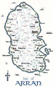
Arran is often said to be a microcosm of the Scottish landscape and, indeed, the Highland Boundary fault neatly bisects the island so that the northern half is wild and mountainous while the southern half is gentler. Both are spectacularly beautiful. Way back in the mists of time between 1800 and 1600BC, Bronze Age inhabitants spent quite a lot of their time erecting stone circles on Machrie Moor on the island's west coast. As ever, the purpose of these stones remains something of a mystery. One of the circles includes three very impressive red sandstone pillars, the tallest of which is just over 18 feet (5.3 m) high. Some 2500 years later, Arran shared the fate of many of Scotland's islands by falling prey to the marauding Vikings. By the 11th century it was established as part of the Norwegian kingdom of Magnus Barelegs, and it was not until 1266 and the Treaty of Perth that it finally became part of the Kingdom of Scotland. Arran has strong connections with Robert the Bruce. Legend has it that it was in the Kings Cave, near Machrie and its stone circles, that the despairing Bruce took heart and courage from the famously determined spider. A little later, Bruce waited at Kingscross Point, looking for a signal from his supporters in Ayrshire that the time was right for him to cross to the mainland and begin his final - and successful - campaign to claim his kingdom. When he saw a flash of light he mistakenly took it as the signal beacon and set sail, only to find that no-one was ready for him. Happily, it is now a matter of history that he did not allow this small set-back to prevent him from re-establishing Scotland's freedom. In 1314, the same year that he comprehensively defeated Edward II's English army at Bannockburn, Bruce gave Arran to the Stewarts of Menteith in recognition of their loyalty to him and his cause. Later that century, when the Stewarts' male line failed, Arran passed to Robert, High Steward of Scotland and husband of Marjory Bruce and eventually, through their daughter, Arran ended up in the possession of John of Islay, Lord of the Isles. By that time the Lordship of the Isles was in virtually constant conflict with the Scottish Crown - indeed, in 1462 John even concluded an anti-Scottish treaty with Edward IV of England. By the end of the century James IV of Scotland had crushed the Lordship of the Isles and in 1503 James, 2nd Lord Hamilton, was granted the Earldom of Arran. For the next 450 years the Hamiltons were to play a prominent part in the island's - and the nation's - history. The island's major fortress was Brodick Castle. This was virtually destroyed by the Lord of the Isles in the 1450s, was damaged during clan battles in 1528 and then in 1544 the Earl of Lennox, acting on behalf of the English king Henry VIII, did his best to destroy it. The Hamiltons rebuilt it in the 1550s, but then rather carelessly lost it in the 17th century when it was captured by the Campbells. No sooner had the Hamiltons got it back again than Oliver Cromwell's troops occupied it. Since then, happily, things have been pretty quiet, and in 1958 the castle was acquired by the National Trust for Scotland and is now open to the public. Brodick Castle has three ghosts; one is a man sometimes seen sitting in the library, another is a grey lady who died of starvation when, suffering from the Black Death, she was "quarantined" in the dungeons, and the third is a white deer said to appear when a Hamilton Clan Chief is about to die. In the 19th century the infamous Clearances, when people were cleared off the land by their landlords to make way for much more profitable sheep, saw the island lose about a third of its population and much of its Gaelic culture. The Hamiltons were not as bad as many landlords, and sometimes built replacement homes for their cleared tenants. The "Twelve Apostles" at Catacol are a row of 12 identical white cottages built by the Hamiltons to house the crofters of Abhainn Bheag who had been moved off their land to make way for sheep. The displaced crofters refused to live in them and the cottages - "the hungry row" - lay empty for two years before being let. Today, Arran and its 3500 inhabitants rely largely on tourism. Our cross-stitch map of Arran has a stitch count of 116 x 189 and, when stitched on the recommended 27-count Linda evenweave, measures approximately 8½ x 14 inches (218 x 346 mm). There are 7 buildings, a lighthouse, standing stones, ferries, puffer, fishing and sailing boats, place names, and a Celtic Cross as the compass.
|
||||||||||||||||||