Inverness-shire
|
|
|
|
Inverness-shire
|
||||||
|
|||||||
|
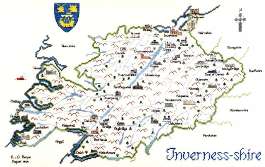
(Click on the picture to see a larger one) Before re-organisation of local government Inverness-shire was Scotland's largest county. It didn't only comprise an enormous area of mainland - in addition, it encompassed the islands of Skye, Harris, North and South Uist, Benbecula and, far away in the Atlantic, the now-deserted archipelago of St. Kilda. Space limitations have meant that our kit only includes mainland Inverness, although Harris (with Lewis) and Skye are available seperately. Superlatives abound in Inverness-shire. Britain's highest mountain, Ben Nevis, looms over Fort William, the Spey, Britain's fastest flowing river, flows through the county, and Loch Ness, Britain's most voluminous loch and Europe's greatest expanse of fresh water, is home to the world's most famous monster. And did you know that Loch Ness holds more water than all the lakes in England and Wales put together? Having said that, it's not as deep as Loch Morar, also in Inverness-shire and also reputedly home to a monster whose appearances apparently herald the death of a Clanranald MacDonald. Here also, at Culloden, was fought the last pitched miltary battle on British soil when, in 1746, the Duke of Cumberland's numerically superior and better disciplined Government army soundly defeated Bonnie Prince Charlie's previously undefeated highlanders. Don't be fooled, incidentally, into thinking that Culloden was a Scottish defeat at the hands of the English - it was strictly Government versus Rebels and there were more kilted highlanders fighting on the government side than on the Prince's. Inverness-shire played a pivotal role in the Jacobite rebellions of the 18th century. Following the 1715 uprising the government built barracks at Inversnaid, Fort Augustus, Ruthven and Bernera, and the ruins of the latter two can still be seen to-day (and are indeed pictured on our map). These did not however deter Prince Charles Edward Stewart (Bonnie Prince Charlie) who raised his standard at Glenfinnan on 19th August 1745. Whether his campaign would ever get off the ground was initially in doubt; few were waiting to greet the Prince and as he and his small band of followers stood disconsolately in the rain he must have thought of giving up there and then. However, the clans did not let him down - Clanranald of MacDonald were the first to turn up and others followed soon after. The Glenfinnan Monument - yes, it's on our map - commemorates the event. Following the Prince's eventual defeat the Government, thoroughly scared, built the massive and heavily fortified barracks at Fort George to ensure that the Highlands did not step out of line again. In fact, the defeat of the clans at Culloden and the subsequent harsh and repressive measures taken against them by the government - the wearing of the kilt and the playing of the pipes were both banned, for example - effectively brought an unhappy end to the traditional clan system. The burgh of Inverness, site of a royal castle through the middle ages, is the undisputed capital of the highlands and currently claims to be one of the fastest growing towns in Europe. Mainland Inverness-shire family names include Fraser, Grant, MacDonnell, Cameron, MacDonald of Clanranald, MacKintosh, MacLeod and Chisholm. Our map of Inverness-shire has a stich count of 248 x 158 and, when stitched on the recommended 27-count Linda evenweave, measures 18¼ x 11¾ inches (467 x 297 mm). There are 37 buildings, fishing boat, place names, compass and crest.
|
||||||||||||||||||
|
Mearnscraft |